Thai Nguyen province has a very convenient location in terms of traffic: from the center of Thai Nguyen city to Noi Bai international airport 50km; about 215km from the Chinese border (in the direction of Lao Cai, about 170km from Lang Son, about 200km from Cao Bang); 75km from the center of Hanoi; 200km from Hai Phong port and 180km from Quang Ninh. Thai Nguyen is the intersection of national highways: National Highway 3 connecting Hanoi - Bac Kan - Vietnam - Tru.ng border gate; connecting with Hanoi - Lao Cai expressway; National Highway 1B connecting Lang Son - Vietnam-China border gate; National Highway 37 connects Quang Ninh - Bac Giang - Thai Nguyen - Tuyen Quang - Phu Tho - Son La.
The map of the current status of the urban and rural system in 2020 of Thai Nguyen province is an overview that vividly reflects the development spatial structure of the province before entering the new planning stage. On the map, the network of urban areas from Thai Nguyen city – the political, economic and educational center of the province – to dynamic cities such as Pho Yen and Song Cong clearly appears, showing the strong development of the southern region and the center of the province. Towns, commune centers and rural residential areas are shown intertwined in the vast mountainous and midland space, showing a harmonious population distribution with the typical hilly terrain of Thai Nguyen. The map not only outlines the current situation of urban-rural distribution but also reflects the disparities, potentials and limitations in the organization of living space, which is an important basis for determining the direction of urban development, planning for new rural construction and forming growth engine areas in the period of 2021-2030. with a vision to 2050.
Thai Nguyen province has geographical coordinates from 20020' to 22025' North latitude; from 105025' to 106016' East Longitude, including 09 district-level administrative units, including 06 districts (Dinh Hoa, Vo Nhai, Phu Luong, Dong Hy, Dai Tu, Phu Binh), 03 cities (Thai Nguyen, Song Cong, Pho Yen); 178 commune-level administrative units, including 128 communes, 41 wards and 09 townships. According to the results of the land inventory in 2019 (total land inventory every 5 years according to the provincial Decision), the total natural area of Thai Nguyen province is 352,196 hectares. The planning boundaries are as follows:
- The North is adjacent to Bac Kan province;
- The South is adjacent to Hanoi capital;
- The West is adjacent to the provinces of Vinh Phuc and Tuyen Quang;
- The East is adjacent to the provinces of Lang Son and Bac Giang.
+ Thai Nguyen is a mountainous province (according to Decision No. 68/UBQD dated August 9, 1997 of the Minister-Chairman of the Committee for Ethnic Minorities and Mountainous Areas on the recognition of communes, districts and provinces as mountainous and highland areas). The terrain of Thai Nguyen is mainly low hills and mountains, gradually distributed from North to South, the area of hills and mountains over 100m high accounts for 2/3 of the province's area, the rest are areas with an altitude of less than 100m. The mountains of Thai Nguyen have a small altitude, distributed in the south of the Ngan Son and Bac Son mountain ranges. The higher terrain is the Tam Dao mountain range, with the highest peak of 1,590m; the eastern slope of the Tam Dao mountain range in the southwestern territory of Thai Nguyen province (including the western communes of Dai Tu district) has an altitude of above and below 1,000m and then quickly decreases to the Cong river valley and Nui Coc lake area.
+ In the East, the terrain has an altitude of 500m - 600m, most of which are limestone massifs with quite similar heights. The south has a lower terrain, including some low mountains rising out of the low hilly areas. The midland hills in the south and the alluvial plains of the rivers are less than 100m high.
+ The topography of Thai Nguyen province slopes in the north-south direction in accordance with the direction of the flow of the Cau River. The right bank of the Cau River has a slope from Northwest to Southeast, the left bank of the Cau River (except for the Southeast part of Vo Nhai district) slopes in the direction from Northeast to Southwest
a) The Thai Nguyen provincial planning for the 2021-2030 period, with a vision to 2050, is the basis for leadership, direction and comprehensive and uniform management in socio-economic development, national defense, security, integration and external relations in the province; serve as a basis for policy making, formulation of investment plans and create a driving force for the development of production, business, social security, security, safety and civilization; striving to become an industrial province developed in the direction of modernity by 2030; is a socio-economic center, a growth pole with a spillover impact on the entire Northern Midlands and Mountainous region; creating a green economy with highly competitive key products.
b) Provincial planning will be an important legal tool of the Party and provincial authorities to administer and manage the province's socio-economic development in the period of 2021-2030.
c) Concretize the national master plan, national sectoral planning, the planning of the northern midlands and mountainous regions at the provincial level in terms of spatial socio-economic activities, national defense and security, urban system and rural population distribution, infrastructure, land allocation, etc use of natural resources and environmental protection on the basis of connecting national, regional, urban and rural planning.
- Methods of investigation, collection and processing of information and data;
- Methods of analysis, assessment, classification, comparison, synthesis, diagnosis and modeling;
- Development forecasting methods and strategic planning;
- Methods of developing scenarios for analysis, evaluation and selection of development plans;
- Expert methods, conferences, seminars;
- Socio-economic mapping methods integrating and applying information technology and geographic information systems (GIS);
- Methods of balancing, analyzing, and evaluating the effectiveness of benefits and costs;
- Methods of participation of organizations, communities and populations;
- The quantitative method uses the growth supply and demand model.
- In addition to the above methods, the consultant has applied a number of other research methods and other technical tools in accordance with the technical process of provincial planning, ensuring the scientificity, practicality and reliability of the methods.
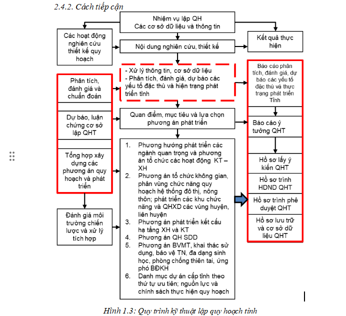
- The process of making the Thai Nguyen Provincial Planning for the 2021-2030 period, with a vision to 2050 has complied with the provisions of Clause 4, Article 16 of the Law on Planning 2017 (Figure 1.2).